Quilt Trail of Pocahontas County
The Quilt Trail of Pocahontas County traverses through the idyllic countryside highlighting the unique and spectacular quilting heritage of West Virginia. The 19 quilt squares chosen for the 2013 Sesquicentennial themed trail are rooted in 19th century origins and Civil War significance. During the celebration of West Virginia’s 150th Birthday and Civil War history, the patterns connect the strong heritage of quilting to the plight so many endured during the Civil War. Quilting provided a way for women to quietly express their sentiments and support a cause while honing the necessary skill of quilting. Today, the art of quilting lives on in Pocahontas County through quilting guilds, quilt raffles, and quilting parties among friends!
Below are the locations which you can view the Sesquicentennial blocks:
- Bear’s Paw: Located off Route 219 near Cooktown on Newman Road
- Bow Tie: Located at the intersection of Route 28 and Route 250, Bartow
- Carpenter’s Wheel: Located on Route 92/Route 28
- Churn Dash: Located on the Green Bank Arts Center building
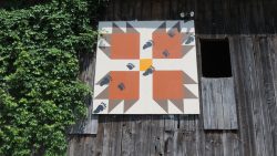
- Corn & Beans: Located one mile South on Route 92 from Route 39 Intersection, Rimel
- Dresden Plate: Located on Route 39, one mile east of Minnehaha Springs
- Drunkard’s Path: Located on Route 219 approximately two miles south of Slatyfork
- Flying Geese: Located on Route 219 in Slatyfork
- Log Cabin: Located on Route 92/Route 28 approximately one mile North of Arbovale
- Rail Fence: Located Route 250, Station 2 Restaurant, Main Street, Durbin
- Shoo Fly: Located Route 250, Main Street Durbin
- Turkey Tracks: Located at the intersection of Route 39 and Route 92, Minnehaha Springs
- West Virginia Star: Located on Route 219, Pearl S. Buck Birthplace, Hillsboro
- Annie’s Choice: Located in Durbin, on the right hand side of Highway 250 and Route 92
- Birds in Flight: Located on 4th Avenue and Main Street, Marlinton
- Churn Dash: Travel approximately 3 miles North of Marlinton on Route 219 and turn right on the Edray-Back Mountain Road about 1/2 mile on the left
- Monkey Wrench: Located on Airport Road – Route 219 one mile North of Marlinton
- Sunset Star: Located 3.8 miles North on Route 92 from Minnehaha Springs
- North Star: Travel approximately four miles North on Route 28 from Huntersville. Turn right on Luster Schrader Road. Travel two miles, turn right onto Sunset Road, .2 miles on the left